232
Field Trip Guide 2 Karst Features of the Northern Black Hills, South
Dakota and Wyoming, Karst Interest Group workshop, September 15,
2005
By Jack B. Epstein
1
, editor, Arden D. Davis
2
, Andrew J. Long
3
, Larry D. Putnam
3
,
J.
Foster Sawyer
4
1
Geologist Emeritus, U.S. Geological Survey, National Center, MS 926A, Reston, VA 20192
2
Chair and Professor, Department of Geology and Geological Engineering, South Dakota School of Mines
and Technology, 501 E. St. Joseph St., Rapid City 57701
3
Hydrologist, U.S. Geological Survey, 1608 Mountain View Road, Rapid City, SD 57702.
4
Hydrology Specialist, South Dakota Geological Survey, Rapid City, SD 57702.
Figure 1. Route map to karst localities in the northern Black Hills.
233
Field trip originates from the headquarters at the Holiday Inn-Rushmore Plaza, 505 North
Fifth Street, Rapid City, SD.
0.0 0.0 Leave Holiday Inn parking lot, turn right on North 5th Street.
0.2 0.2 Turn right on Omaha Street.
0.7 0.5 Intersection with East Blvd, continue straight on Rte 44 West/79 North. Ahead, water gap
in “Dakota hogback” comprising Lower Cretaceous and Jurassic rocks.
1.8 1.1 Stoplight at Deadwood Avenue, continue straight on West Chicago Street.
2.4 0.6 South Dakota Cement Plant on right, utilizes Minnekahta Limestone quarried nearby to
the north.
2.9 0.5 Stoplight, continue straight on West Chicago St.
3.6 0.7 Road turns right and becomes Nemo Rd. (County Rd. 234).
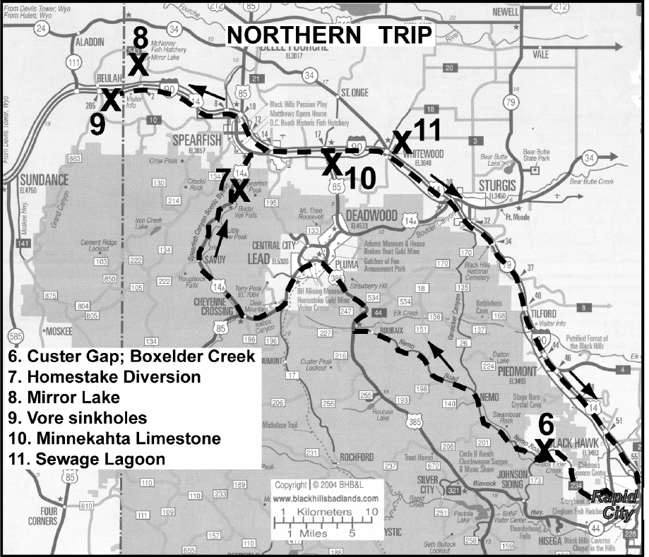
4.5 0.9 Road cut through Minnekahta Limestone, the major material for aggregate, cement, and
lime in the Black Hills. It is a thin (averaging about 40 feet), laminated limestone with minor karstic
features including joint solution widening and precipitation of calcite, sinkholes, and small caves. Second
-
ary porosity enhanced in places by small scale faulting and folding (figure 2). Opeche Shale exposed under
the Minnekahta just up the road.
5.3 0.8 Sandstone near the top of the Minnelusa Formation.
5.6 0.3 Red beds in the Minnelusa.
Figure 2. Typical small-scale deformation in the Minnekahta Limestone and associated jointing
which produce a secondary porosity in the limestone.
234
6.3 0.7 Brecciated red and yellow sandstones in the Minnelusa. Caves higher in the cliff. Burnt
trees from 1988 forest fire on left.
8.4 2.1 Red shale in the Minnelusa on left are probably the “red marker”, interpreted to be an
unconformity and soil horizon near the Permian-Pennsylvanian boundary (Fahrenbach and Fox, 1996).
9.0 0.6 Cross Boxelder Creek.
9.5 0.5 “Red marker?” on left.
9.9 0.4 Brecciated Minnelusa.
11.5 1.6 About 150 feet to south of road is the grave of Pvt. James A, King who died in 1874 during
General Custer’s first visit to the Black Hills.
11.6 0.1 Entering Black Hills National Forest.
12.2 0.6 Pahasapa Limestone exposed in creek on left.
12.5 0.3 Pahasapa Limestone.
12.8 0.3 Cross Boxelder Creek.
13.2 0.4 Custer Gap is the small ravine in the Pahasapa Limestone on right through which the
General Custer expedition exited the central Black Hills. About 300 feet west of the ravine is the exposed
contact of the Pahasapa Limestone and Englewood Formation. The flow of Boxelder Creek normally sinks
into the Pahasapa several hundred feet to the east during the fall and winter.
STOP 6: CUSTER GAP, DYE TRACING IN BOXELDER CREEK
Leaders: Foster Sawyer
Exposures of the Pahasapa Limestone form the cliff walls along Boxelder Creek at this stop near Custer
Gap named for the 1874 expedition of George Armstrong Custer who utilized this break in the canyon walls
to exit the Black Hills with his wagon train. The Pahasapa Limestone, also known as the Madison aquifer,
is approximately 300 to 400 feet thick (91-122 m) in this vicinity, and consists of medium-crystalline, white,
beige, and gray limestone and dolomite with thin chert beds, local solution breccia, and caves (Cattermole,
1969; Fahrenbach and Sawyer, 2001). Published stream gage data (Hortness and Driscoll, 1998) indicate
that this reach of Boxelder Creek loses up to 50 ft
3
/s (1.42 m
3
/s) of streamflow to the underlying limestone
which constitutes the largest streamflow loss zone in the Black Hills uplift. Field observations and geologic
mapping over a distance of several miles along Boxelder Creek have resulted in identification of at least six
areas underlain by swallow holes (Sawyer and Jarrell, 2000; Strobel and others, 1999; Fahrenbach and Saw
-
yer, 2001). Streamflow is lost to swallow holes (Figure 3) and partially regained from springs multiple times
as water moves downgradient through this complex disappearing stream system.
235
Previous dye-tracing activities (Rahn and Gries, 1973; Greene, 1999) have illustrated some of the
mechanics of surface-water and ground-water interactions associated with this series of swallow holes along
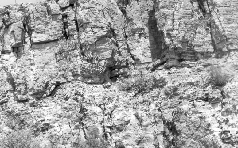
Boxelder Creek, as well as with adjacent surface-water drainage basins. In the spring of 1968, 1 lb (0.45 kg)
of fluorescein dye in 2.5 gal (9.5 L) of water was injected into a swallow hole (Figures 4 and 5) in this vicin
-
ity. The dye appeared downgradient at Gravel Spring in 1 hour and 8 minutes, traveling a distance of about
2,200 ft (670 m) at a subsurface velocity of approximately 0.37 mi/hr (0.60 km/hr). The dye also appeared
at Doty Spring in 3 hours and 2 minutes, much faster than the surface-water flow rate from Gravel Spring
to Doty Spring, and it reached Dome Spring in 6 hours and 35 minutes. Another dye test in the fall of 1968,
using 15 gal (56.8 L) of Rhodamine WT dye, demonstrated that water lost to swallow holes in one drainage
basin can reappear in an adjacent drainage basin when the dye appeared within 34 days at City Springs,
approximately 6 mi (10 km) away in the Rapid Creek watershed (Rahn and Gries, 1973). Subsequent dye
tests in 1993 (Greene, 1999) detected dye in four wells within the Madison aquifer in the Rapid City area
between 26 and 49 days from the initial injection time.
Figure 3. Boxelder Creek disappearing into the alluvium overlying
swallow holes in the Pahasapa Limestone near Custer Gap (From
Rahn and Gries, 1973).
Figure 4. Injecting dye in 1968 into the swallow hole in the Pahasapa Lime-
stone along Boxelder Creek near Custer Gap (From Rahn and Gries, 1973).
236
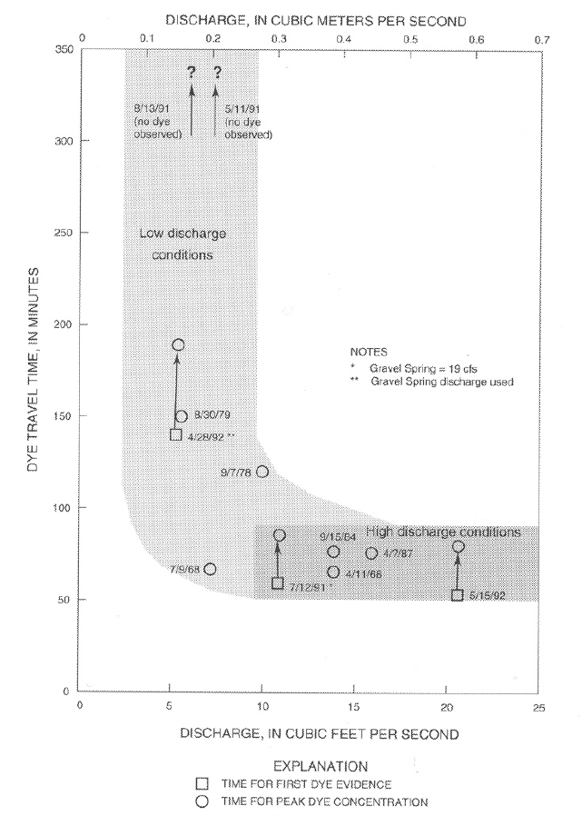
Numerous dye tests at Custer Gap have also yielded information regarding the effect of the discharge
rate of Boxelder Creek on ground-water velocity and flow paths within the Pahasapa Limestone (Rahn
1992, Strobel and others, 2000). Figure 6 shows dye travel times from Custer Gap to Gravel Spring from 11
dye tests under varying discharge conditions. Dye that was injected during discharge rates greater than
approximately 10 ft
3
/sec (0.28 m
3
/sec) had a relatively constant first appearance time of about 60 minutes;
however, dye that was injected during discharge rates of less than 10 ft
3
/sec (0.28 m
3
/sec) usually took two
hours or more to arrive at Gravel Spring and sometimes did not appear at all. Under low discharge
conditions the entire water table may be at a lower level causing the dye to take a different pathway through
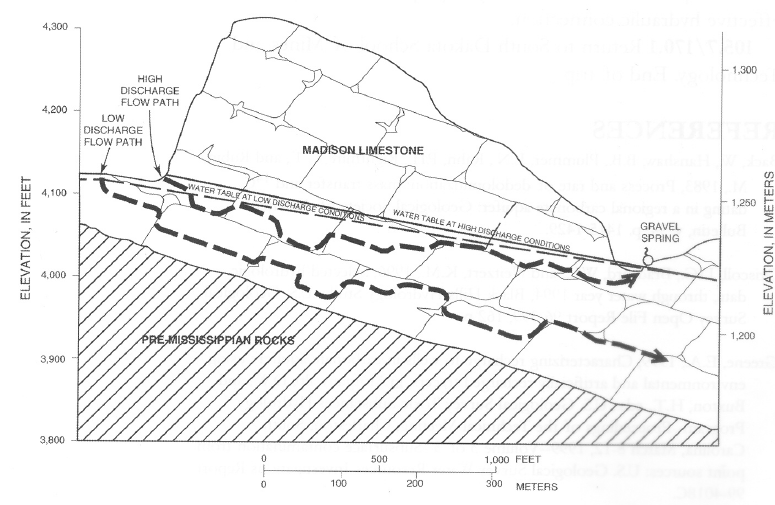
the limestone and the dye may never reach Gravel Spring (Figure 7).
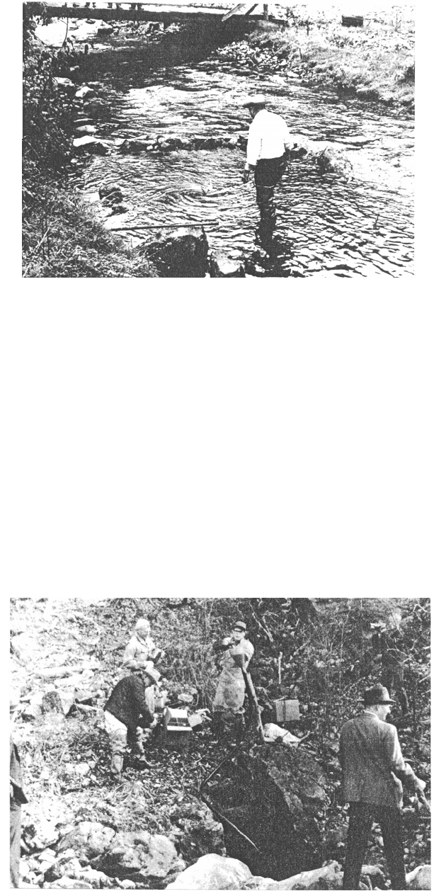
Figure 5. Map of Boxelder Creek swallow hole area (from Strobel and others, 1999).
237
Figure 6. Boxelder Creek discharge and dye travel time from Custer
Gap to Gravel Spring (from Strobel and others, 2000).
238
Figure 7. Generalized hydrogeologic section from Custer Gap to Gravel Spring,
showing conceptualized ground water flow paths for high water table and low
water table conditions (from Strobel and others, 2000).
The rapid ground-water velocities associated with the Pahasapa Limestone (Madison aquifer), and the
variable subsurface flow paths that allow ground water within the limestone to migrate across surface water
drainage basin divides, pose significant challenges to protection of drinking water for cities and
communities that utilize this highly productive aquifer. Streamflow loss zones such as the one along
Boxelder Creek at Custer Gap are particularly vulnerable to contamination, and could essentially function
as locations of point recharge to the aquifer for microbial or chemical contaminants resulting from spills,
leaks, accidents, intentional contamination, or malfunctioning septic tanks and drain fields (Davis and
others, 2000).
Continue northwest on Nemo Road.
13.9 0.7 Knobbly weathering sandstone in Deadwood Formation on right.
15.4 0.5 Cross Boxelder Creek. Deadwood Formation exposed.
15.7 0.5 Boxelder Creek.
15.3 0.6 Boxelder Creek.
15.6 0.3 Meade-Pennington County line.
15.7 0.1 Cambrian-Precambrian unconformity. For the next 33 miles the road will traverse many
Precambrian rocks (see Redden and Fahrenbach, 1996).
16.8 1.1 Metagabbro sill on right.
17.2 0.4 Cross Boxelder Creek. Deadwood exposed on left.
239
17.8 0.6 Steamboat Picnic Ground.
19.3 1.5 Pahasapa Limestone forms cliff to right, overlying covered slope of the Englewood
Formation, then reddish sandstone of the Deadwood Formation below.
19.7 0.4 Estes Rd. (FS 208) on left. Open cut mine to northeast is in banded iron formation which
produces iron ore as an additive for the State Cement Plant seen at mileage 2.4.
20.8 1.1 Estes Creek Road.
21.2 0.4 Town of Nemo.
21.6 0.4 Basal Deadwood sandstone on left.
21.8 0.2 Wonderland Cave to right.
24.5 2.7 Town of Novak.
26.1 1.6 Cross Boxelder Creek.
32.7 6.6 Elk Creek. Old Cloverleaf (Uncle Sam, Anaconda) gold mine dumps on left. Production of
$900,000 in gold associated with galena, sphalerite, pyrite, and chalcopyrite in milky quartz was from
1878-1937.
34.2 1.5 Junction, turn right on US 385 North. Deadwood Formation on right.
34.9 0.7 Cross Bear Butte Creek.
40.8 5.9 Yates shaft of Homestake gold mine visible to northwest.
41.6 0.8 Deadwood.
41.7 0.1 Turn left on US85 South and enter Lead.
43.1 1.4 Homestake gold mine on right. Visitors park on right shows beautiful exposures of
Tertiary rhyolite dikes cutting Precambrian rocks parallel to foliation, then intrudes as sills in the lower
Deadwood Formation which caps hills to north. The present underground workings extend to the
8,000-foot level. Total gold production since 1876 exceeds 39 million ounces. Time permitting we will
hop out for a quick view of the open pit. Proceed through Lead on Main street.
43.7 0.6 Stop Light, turn left on US85/US15A.
48.9 5.2 Road to Terry Peak on right
49.4 0.5 Pahasapa Limestone to right.
50.2 0.8 Whiteport Dolomite on right.
50.3 0.1 Green shale in the Icebox Shale of the Winnipeg Group on right.
50.5 0.2 Deadwood-Winnipeg contact on right.
240
51.4 0.9 Cheyenne Crossing, turn right on US 15A into Spearfish Canyon. Area of smaller trees on
left mark the location of a landslide.
52.9 1.5 Townsite of Elmore.
55.7 2.8 Dam diverting water to Homestake Hydroelectric No. 2 aqueduct.
56.0 0.3 View of Pahasapa Limestone cliffs rimming the canyon ahead.
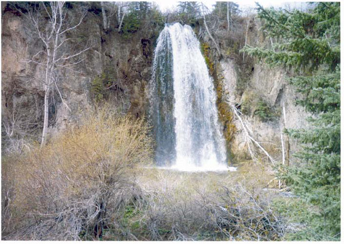
56.6 0.6 Town of Savoy and Spearfish Falls.
STOP 7: HOMESTAKE MINING COMPANY AND SPEARFISH CREEK
Leaders: Larry Putnam, Andrew Long, Ron Koth
Walk down trail to see abandoned aqueduct and Spearfish falls.
The Homestake Gold Mine was one of the early enterprises associated with the Gold Rush of 1876 in
the northern Black Hills of what was then Dakota Territory. The mining community of Deadwood was the
center of the gold fever, with tents, sawmills, log houses, and salons springing up seemingly overnight. But
the real action would happen three miles away “over the hill” where brothers Fred and Moses Manual and
their partner Hank Harney located their Homestake claim on April 9, 1876. Moses liked what he saw of an
outcropping of a vein of ore, referred to as a lead and pronounced “leed.” Soon more prospectors
materialized, and no time was lost in selecting a site for a new town (Severson, 2005).
With a population of 8,392 in 1910, Lead was the second largest community in South Dakota. The
employment opportunities for not only miners, but also laborers and mechanics, were excellent. Throughout
the decades to come, the City of Lead and the Homestake Mine were confronted with challenges ranging
from an epidemic of Spanish influenza, nearby forest fires, and even a fire in the mine, which was
extinguished by a deliberate flooding of the mine and subsequent dewatering with no ill effects to the mine
or its equipment. But on the whole, the city and its residents prospered as a result of the mine. In the early
1930s, as the rest of the nation suffered economic hardship throughout the Great Depression, the manage
-
ment of Homestake set a shorter work week with an increase in wages and provided end of year bonuses to
workers (Severson, 2005).
Today, the mine reaches a depth of 8,000 feet, and its network of 370 miles of underground workings
provides direct access to a subterranean volume of rock totaling nearly 8 cubic miles. Prior to closing in
December 2001, the Homestake mine had been in continuous operation for 125 years and had produced
more than 40 million ounces of gold, ranking it among the largest gold deposits in the world (Duke, 2005).
Water and power were important resources to new technologies incorporated in the mining enterprise.
George Hearst pursued numerous legal suits in consolidating mining claims to build control of the
Homestake Lode; however, he also vigorously pursued water rights recognizing the importance of water in
building an industrial gold mine (Fielder, 1970). The adjacent Spearfish Creek drainage basin with
numerous headwater springs discharging from the Pahasapa Limestone was a promising water resource.
241
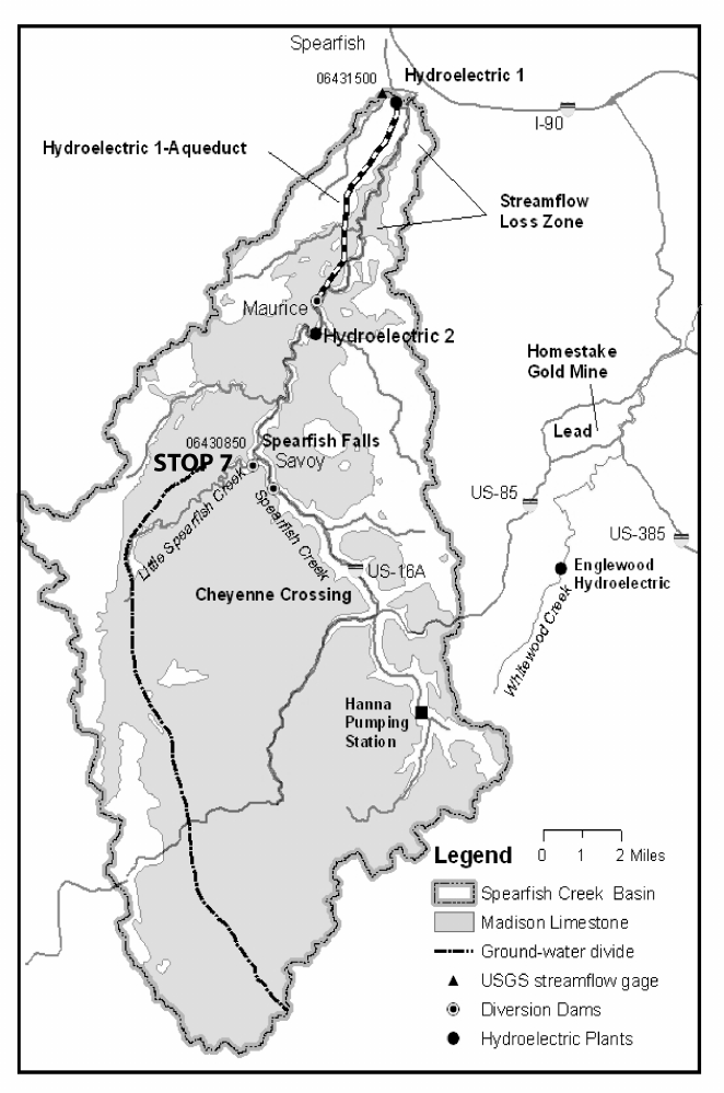
The Spearfish Creek drainage basin above the streamflow gage at Spearfish (06431500) encompasses
about 168 sq. mi. (fig. 8). About 70 percent of this area includes the outcrop of the Pahasapa Limestone.
Average precipitation on the drainage basin ranges from about 23 to 28 inches per year with the higher
values in the central part of the basin (Driscoll and others, 2000). Average recharge to the Pahasapa Lime-
stone ranged from about 4 in/yr in the north part of the basin to about 8 in/yr in the south and central part of
the basin (Carter and others, 2001b). The land surface altitude in the basin ranges from about 7,000 feet at
the highest peaks in the south to 3,640 feet above sea level at the streamflow gage in Spearfish.
Figure 8. Location of Spearfish Creek and selected hydrologic features.

242
Recharge to the Pahasapa Limestone west of the ground-water divide (Carter and others, 2001a) flows
to the west where ground-water merges with eastward regional flow, then turns to the north or south, and
then east around the Black Hills. This recharge is a potential source of water for the numerous artesian
springs northwest of Spearfish, some of which will be visited in STOP 8.
Direct surface runoff from parts of the basin where the Pahasapa Limestone outcrops is rare with most
streams gaining flow from springs discharging from the Pahasapa Limestone. The mean streamflow (WY
1947-2004) for Spearfish Creek at Spearfish was 55.6 ft
3
/s, with the highest annual mean of 106 ft
3
/s and
the lowest annual mean of 27.1 ft
3
/s (U.S. Geological Survey, 2005). The drainage area for Little Spearfish
Creek, a tributary to Spearfish Creek, includes mostly Pahasapa Limestone and the mean streamflow (WY
1997, and 1999-2004) was 16.7 ft
3
/s, with the highest annual mean of 23.1 ft
3
/s and the lowest annual mean
of 11.7 ft
3
/s (U.S. Geological Survey, 2005). The stream reach from Spearfish to about 5 miles south of
Spearfish is a losing reach with a maximum loss rate of about 21 ft
3
/s when streamflow is present (Hortness
and Driscoll, 1998).
Streamflow that recharges the Pahasapa Limestone in this losing reach rapidly moves downgradient to
the north through conduits. Dye injected in 2003 when streamflow was present in the upper reaches of the
loss zone arrived in 6 days at a public supply well completed in the Madison aquifer and located north about
2 miles. Dye also was detected within a few months at several Spearfish public supply wells completed in
the Madison aquifer and located about 3 to 4 miles north of the dye injection site.
Headwater springs in the Spearfish Creek basin above Cheyenne Crossing were collected by
Homestake Mining Company with an extensive system of flumes and ditches and a pumping station that
delivered water to Lead. As the mining enterprise grew, water for the growing communities of Lead and
surrounding towns increased along with the water needed for the mining and milling operations. Many miles
of cast iron tile and wood stave pipeline, included in the water conveyance system, were installed by hand
and horse labor (Fielder, 1970). A replication of a section of a redwood stave pipe is shown in figure 9.
Figure 9. Replication of wood stave pipe.
243
Homestake Mining Company was well established as an industrial gold mine by the beginning of the
1900’s and was actively bringing new technologies to the mine. An important change involved the
conversion from steam to electrical power.
Three hydroelectric power plants were constructed beginning with the Englewood hydroelectric
located in the Whitewood Creek Basin (fig. 8) in 1906. Water for the Englewood hydroelectric originates
from springs in the upper reaches of the Spearfish Creek Basin and is delivered by flumes and ditches to the
Hanna Pumping Station. From there the line is joined by gravity flow from collection lines in other draws
and continues to the Englewood hydroelectric station. From there the water travels to a reservoir above Lead
(Johnson, 1931).
The early experiments with converting mining equipment to electric power using the generation station
at Englewood were successful and the transition to electric power continued. Though the cost would be
about a million dollars, plans were begun for the building of Spearfish Hydroelectric Plant No. 1. About four
miles of tunnel work divided into eight sections would be necessary to divert the water in Spearfish Creek
for industrial use (Fiedler, 1970). A dam constructed near Maurice diverted water through the tunnel
(fig.
10). The Spearfish Hydroelectric Plant No. 1was finished in 1912 and was capable of diverting all of
the streamflow in Spearfish Creek except during very high flow conditions.
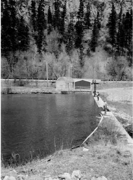
Figure 10. Diversion dam for Hydroelectric 1.
244
The diversion of water through the aqueduct probably caused a decline in the potentiometric surface in
the Madison and Minnelusa aquifers because of reduced recharge in the early 1900’s (Greene and others,
1999). A report by Dr. B.W. Evermann in 1896 to the U.S. Commissioner of Fish and Fisheries
documenting investigations for potential fish hatchery sites described several springs in the Spearfish area
(U.S. Commission of Fish and Fisheries, 1896). He characterized the site at Spearfish in this way: “If fish
cultural work should ever be undertaken at any place in the Black Hills, the most satisfactory natural
conditions could probably be found here.” The D.C. Booth Historic National Fish Hatchery, formerly
Spearfish National Fish Hatchery, was established in 1896. By the 1940s, the water supply at Spearfish had
become increasingly undependable. This resulted in the acquisition of land 12 miles west of Spearfish from
Judge McNenny and the State of South Dakota specifically to rear fish (near springs described in STOP 8).
The Booth hatchery ceased operations in the mid-1980s and reopened with a new mission and partnerships
to help preserve the U.S. Fish & Wildlife Service's historic and cultural heritage (U.S. Fish and Wildlife
Service, 2005). The springs that Evermann described are no longer present suggesting that the Madison and/
or Minnelusa aquifers were the source for the springs.
In 1916, Homestake began plans for a second hydroelectric plant (fig. 8) located farther upstream; the
plant was completed in 1918 (Fiedler, 1970). Flumes and ditches rather than a tunnel were used to transmit
the water to the plant. Wood stave and steel pipes built on shelves excavated on the hillside were used for
many of the flumes. The water was diverted from Little Spearfish Creek and Spearfish Creek (fig.1) above
Savoy bypassing Spearfish Falls to Hydroelectric 2, which is located about 6 miles downstream. Most of
the streamflow was diverted around this 6 mile reach of stream.
Economic development in the northern Black Hills occurred over 80 years with these water diversions
in place. With the closing of the mine, potential changes in this water conveyance system involve several
hydrologic and environmental issues. The hydroelectric 1 diversion resulted in water being transmitted
downstream around the loss zone for about 80 years. The result was a decrease in recharge to the Pahasapa
Limestone. Returning the stream to the natural channel would change the character of the stream that has
been flowing through the city of Spearfish, especially during low flow conditions. Downstream irrigation
would also be affected. Water reentering the loss zone would increase Madison aquifer water levels over
time. However, estimation of potential spring discharges in the Spearfish area and water-level responses are
difficult because of the complex geologic processes involved in spring formation around the Black Hills.
The diverted streamflow for Hydroelectric 2 is being returned to Spearfish Creek and Little Spearfish
Creek as part of the Final Conceptual Restoration and Compensation Plan for Whitewood Creek and the
Belle Fourche and Cheyenne River Watersheds, South Dakota (South Dakota Department of Game, Fish
and Parks and others, 2005). The plan was developed as a guide for selection and implementation of site-
specific activities to best compensate the public for lost, injured or damaged trust resources and services due
to hazardous substance releases into State waters from the Homestake Mining Company of California,
Incorporated. The Comprehensive Environmental Response, Compensation, and Liability Act (CERCLA),
commonly known as Superfund, is the federal law guiding this process and defines restoration in various
ways in order to best compensate the public. As a result of this agreement, Homestake has transferred its
water right on Little Spearfish Creek.
South Dakota Department of Game, Fish and Parks restored the natural flow of Little Spearfish Creek
and Spearfish Falls in November 2003 for the first time since 1917 (fig. 11). The increase in flow in the
stream reach below Savoy has improved trout habit in a very scenic part of Spearfish Canyon. SD Game,
Fish and Parks biologists anticipate the potential for the naturally reproducing population of rainbow trout
previously restricted to the 1-mile reach below Hydroelectric 2 to move upstream into this reach. Below
245
the Maurice intake for about 3.5 miles, a base flow exists in Spearfish Creek that allows for small numbers
of trout to maintain a naturally reproducing population. With cooperative management, this 3.5-mile reach
of stream could be improved to host a much improved trout population and fishery if about 10 ft
3
/s were
allowed to bypass the Maurice intake.
Figure 11. Spearfish Falls where Little Spearfish Creek joins Spearfish Creek.
Continue north on US 16A
56.7 0.1 Intersection with FS 222 to Roughlock Falls on left. The falls drop over the type locality of
the Roughlock Member of the Winnepeg Formation (Ordovician). Continue straight on US 16A.
57.2 0.5 Cliff with Pahasapa Limestone overlying the pink-colored Englewood Formation ahead.
Road continues along Spearfish Creek and following the Deadwood-Winnipeg contact.
58.4 1.2 Cross Iron Creek.
58.6 0.2 Outcrop on left exposes rocks of the Winnipeg Formation through Pahasapa Limestone
(Fahrenbach and Fox, 1996, Stop 3).
246
60.0 1.4 Whitewood Dolomite up through Pahasapa Limestone exposed on left.
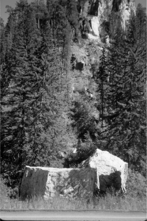
60.5 0.5 Two car-sized blocks of Pahasapa Limestone fell into Spearfish Creek in 1994 on right
(figure 12).
60.80.3 Tertiary phonolite sill concordant with Winnipeg strata on left.
61.5 0.7 Winnipeg strata between phonolite sills on left.
61.7 0.2 Homestake Mining Company Hydroelectric Plant No. 2
62.1 0.5 Landslide on left due to heavy spring rains in 1995.
62.6 0.5 Homestake Dam diverting water through four-mile tunnel to Hydroelectric Plant No. 1 in
Spearfish.
63.0 0.4 Landslide.
Figure 12. Avalanche chute and rock-fall boulders derived
from Pahasapa Limestone.
247
63.4 0.4 Large roadcut on left in Deadwood Formation contains interbedded glauconitic sandstone,
shale, intraformational conglomerate, carbonate beds, and horizontal burrows. The section is capped by
Skolithos (vertical burrows) sandstone. A vertical fault with about 3 ft of displacement is in the middle of
the roadcut. A small flexure at south end is probably the result of Tertiary intrusion.
63.6 0.2 Deadwood Formation on left.
63.8 0.4 Bridal Veil Falls on right. A Tertiary sill and dike of nepheline syenite within the
Deadwood Formation is resistant to erosion and forms this waterfall on Rubicon Creek (Lisenbee and
others, 1996, p. 126).
64.5 0.7 Small adit in Deadwood Formation on left follows a porous conglomerate.
65.0 0.5 Roadcut on left in steeply dipping Deadwood Formation crosscut by dikes along west
flank of a phonolite laccolith.
65.9 0.9 Roadcut on left at sharp bend exposes the upper Englewood Formation and lower
Pahasapa Limestone.
66.4 0.5 Dry creek bed of Spearfish Creek--now a losing stream.
67.5 1.1 Minnelusa Formation overlies Pahasapa ahead.
68.1 0.6 Leaving Black Hills National Forest.
68.4 0.3 Spearfish Creek; brecciated Minnelusa to left.
68.6 0.2 Minnekahta Limestone on Opeche Shale overlying Minnnelusa on right.
69.3 0.7 Winterville Drive on left leads to D.C. Booth National Fish Hatchery, a worthwhile visit.
Spearfish production well on left completed in the Madison aquifer to a depth of 842 feet and production
of about 2,000 gallons per minute.
69.4 0.1 Spearfish Formation on left. Lookout Mountain straight ahead.
69.6 0.2 Stop sign. Turn right on US 15A.
71.1 1.5 Stop sign. Turn left towards I-90.
71.3 0.2 Turn left on I-90 West, Exit 15. Crow Peak at 11 o’clock, a Tertiary intrusive.
72.3 1.0 Lookout Mountain to right capped by sandstone of the Lakota Formation (Cretaceous).
Housing development to right makes use of a terrace in gypsum of the Gypsum Spring Formation.
73.0 0.7 Exit 12. City of Spearfish. To left is a hill composed of old landslide debris derived from
all units in Lookout Mountain. Old topographic maps show that the hill is an erosional outlier and is not a
result of I-90 excavation.
73.5 0.5 Lookout Mountain to right exposes red beds of the Spearfish Formation (Triassic) at
bottom, overlain by prominent white gypsum of the Gypsum Spring Formation (Jurassic), then green shale
and yellow sandstone of the Sundance Formation (Jurassic), and capped by sandstone of the Lakota
Formation (Cretaceous) in the core of a syncline. During construction of I-90 solution cavities in the
gypsum had to be filled for stability (Rahn and others, 1977).
248
74.9 1.4 Exit 10. US 85N to Belle Fourche. Continue on I-90W. Gypsum beds in the Gypsum
Spring Formation.
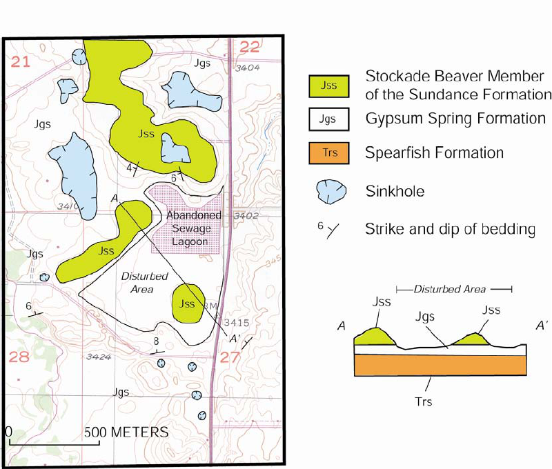
In 1972, the City of Spearfish constructed a sewage lagoon two miles north of here. The lagoon leaked
into sinkholes and was abandoned in favor of a water-treatment plant (Rahn and Davis, 1996; Davis and
Rahn, 1997). The city considered plans to convert the lagoon site into a recreation area with construction of
buildings and light towers. The Public Works Administrator requested the USGS for a judgment on the
potential for subsidence at the site. A geologic map was prepared (figure 13), similar to one prepared by
Davis (1979, fig. 4) showing that at least ten sinkholes, one of which is about 1,000 feet long, had developed
in the gypsum. This hydrogeologic information was subsequently used by the city planners in their decision
to abandon the project.
Figure 13. Geologic map of the abandoned sewage lagoon area west of US 85, 2 miles north of I-90,
Spearfish, SD. (From Epstein, 2003).
77.2 2.3 Crow Peak to the left comprises an intrusion into the core of the LaFlamme anticline. Dip
slope in the Minnekahta Limestone ahead.
249
78.6 1.4 Undulations in the Minnekahta Limestone in the wide crestal zone of the LaFlamme
anticline probably reflect subsidence in the underlying Minnelusa Formation due to solution removal of
anhydrite. Several Pleistocene terraces are well developed in the Red Valley to right.
80.5 1.9 I-90 curves to the left following the configuration of the Minnekahta Limestone in the
LaFlamme anticline.
82.2 1.7 Minnekahta heads south on the west limb of the LaFlamme anticline. Interbedded gypsum
in the Spearfish Formation to right.
82.9 0.7 Exit 2. Turn right towards McNenny State Fish Hatchery.
83.2 0.3 Stop sign. Turn right on US 15.
83.4 0.2 McNenny Road, turn left. Many residual silicified sandstone boulders to right derived
from the Lakota Formation and let down approximately 1,000 feet to their present position as the softer
sediments of the Spearfish Formation were eroded away.
83.55 0.15 Flowing well on left and two small sinkholes on right.
84.1 0.7 Scarps and very shallow depressions in Spearfish due to solution-collapse in gypsum.
84.2 0.1 Turn left towards McNenny State Fish Hatchery and then left towards Mirror Lake. Hill in
distance to west is capped by the Stockade Beaver Member of the Sundance Formation atop the Spearfish
in a shallow syncline. Hills to north comprise well-exposed rocks from the Spearfish to the Lakota.
Numerous small sinkholes in red beds of the Spearfish formation in field to the southwest and in the entire
surrounding area are due to solution of interbedded gypsum (figure 14).
